Answer
The literal meaning of geothermal heat is the heat in the earth that exceeds the heat on the surface of the earth. It has long been known that the temperature increases the deeper we go under the earth's surface. Phenomena such as volcanic eruptions and hot springs have always been irrefutable proof of this fact. With increased harnessing of geothermal power in the 20th century, the term has become more strictly defined and is now primarily used in connection with locations where hot water and steam come up through the surface in so called geothermally active areas. In the University of Iceland Dictionary,
Orðabók Háskólans, the word for geothermal heat is recorded very frequently over the last two hundred years, with the oldest record being from the end of the 18th century.
The conditions needed for geothermal heat in this narrow definition of the concept is that the earth's crust is sufficiently hot and that there are enough fissures, cracks and permeable rock to allow water to percolate and carry heat from the deeper warmer strata to the surface. These conditions are present in countries with volcanic activity, like Iceland, where the earth's plates touch and form, but are unlikely to be in regions other than these. Earthquakes are also irrefutable evidence that the earth's surface plates are breaking and moving. In the earthquakes in June 2000, water channels in the earth's crust in South Iceland either widened or narrowed, which was clearly evidenced in many drill holes in the region. So it is no coincidence that there is considerable geothermal heat in the countries main earthquake regions.
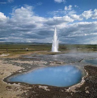 The Geysir area in Haukadalur.
The earth's crust in Iceland is relatively hot because its lower strata are mostly formed by magma intrusions that have solidified before they reached the surface. It is hottest under eruption and continental drift belts and becomes cooler the farther it is from such belts, where the crust is older. It is thought that under most of the country's high geothermal heat areas, which are all in belts of volcanic activity, that there are magma intrusions related to the activity and that they are the main source of the geothermal heat. Low heat areas are those where the crust is colder, but sufficient to heat water to between 50 and 150 °C. Today, people sometimes refer to "cold" areas where geothermal heat has not been found, but it would be more accurate to say "dry" areas as there is always some heat in the crust but there may be little or no water to bring the heat to the surface.
When one has to make a distinction between heat in the earth and the energy that is brought to the surface with water or steam, one refers to the latter as geothermal heat. In Iceland we speak of geothermal water plants (or steam plants) rather than simply geothermal plants. Geothermal heat is measured in energy units, such as joules or megawatt hours. But utilities distributing this kind of energy have been classified as distributing heat, which is a convention dating back to early in the 20th century. But there is a tendency today to replace this classification with the more general term "energy supplier" for utilities that distribute both hot water and electricity (e.g. Reykjavík Energy). This is unfortunate as geothermal district heating systems were a peculiarly Icelandic phenomenon and the Icelandic word "hitaveita" was becoming internationally used to describe such systems, in the same way that the word "geyser" became the generic name for spouting hot-springs in many languages.
Temperature gradient measurements are commonly used to research thermal conditions in the earth's crust. The temperature gradient is the increase in heat by depth and is measured in °C for each metre or kilometer in the earth's crust. Shallow holes are drilled, 50-100 metres, and the heat measured at varying depths. Common levels of temperature gradient in Iceland, where there is no geothermal activity, are in the range of 50 to 100 °C/km. A significantly higher temperature gradient normally indicates that there are veins carrying geothermal water in the underlying strata. This method of prospecting for geothermal water has been used widely in Iceland, to good effect, in areas where there have been few surface indications of thermal activity. Other methods have also been used to evaluate possibilities for geothermal heat, e.g. by measuring earth conductivity, but the temperature gradient measurements give the best indication of underlying geothermal heat.
Geothermally active areas have varying natural surface characteristics. Warm springs, pools, hot springs, fumaroles, mud pots, precipitations of calcium, silicates and sulphur, and colorful soil, paticularly in areas of high thermal activity, are all natural indications of geothermal activity. Those are the external indications of the movement of heat through the earth's crust.
Many geothermally active areas are gems of nature. Examples of such environments in Iceland are to be found in the vicinity of the Torfajökull Glacier, in Kverkfjöll, Námafjall and Þeystareykir. The Geysir area in Haukadalur is without doubt Iceland's most famous geothermal area and has been a fascinating subject of research for both Icelandic and foreign scientists. The name of the largest hot spring in this area, "Geysir", was adopted in English as a general name for a hot spring, and is written as "geyser". There is for example a geyser area in California and on the Kamchatka Peninsula on the east shore of Siberia. Well known geothermal areas abroad are e.g. the Yellowstone National Park in Wyoming in the USA, which is the world's largest hot spring area, Pamukkale in Turkey, with its chalk precipitation terraces, and the Taupo belt of volcanic activity in New Zealand, which until recently had the world's most powerful hot spring.
Translated by Paul Richardson.
Image: Mats: Icelandic Image Gallery © Mats Wibe Lund